Resources
Newsletter
Stay up to date and with the latest news, projects, deals and features.
Subscribe
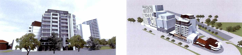
Petridis Architects have submitted to the City of Yarra designs for a new development that will make use of two old sites at 205 - 211 Queens Parade and 6 - 12 Dummett Crescent to bring a new residential opportunity to Clifton Hill.
The site is approximately 1450 square metres in area with a 31.69 metre southern frontage and a 29.51 metre eastern frontage on Dummett Crescent, plus a 27.43 metre north-western frontage along the Queens Parade service road.
In the past, both sites had individual uses that benefited the community, but have now been more or less abandoned and have fallen into disrepair. The site fronting Dummett Crescent was once home to a concrete car parking area and single storey warehouse, but is now currently vacant. Facing Queens Parade, the site currently hosts an old double storey industrial brick building with a distinctive art-deco façade that was later adapted into a restaurant and bar. That establishment was once known as the Mosskito Bar but eventually became the Skinny Elephant, however the building is no longer in business.
About the project
Petridis Architects' application proposed a multi-storey building with three basement levels underneath and 116 dwellings above. In between, the buildings intends on having a ground floor restaurant that could hold up to 150 patrons.
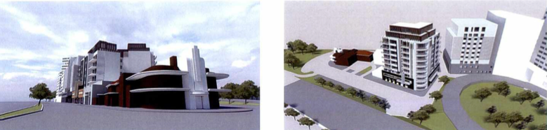
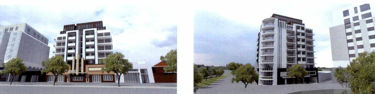
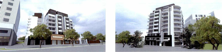
The multi-storey facet of the development is made up of a nine story building that will front to Queens Parade, and an 11 storey building that will primarily front Dummett Crescent.
At ground level, the restaurant and foyer for the apartments is proposed for the front building which faces the Queens Parade frontage. The restaurant has an overall area of 455 square metres. According to the proposal, the Dummett Crescent frontage is to be occupied by four dwellings, the entrance and foyer for the upper levels of the rear building, a bicycle storage room and the double width vehicle entrance.
A central, paved and landscaped courtyard between the buildings is provided. The buildings are separated by the courtyard, but connected along the south side by balconies.
Inside the three basement levels will be:
120 car spaces – 38 on level one, 41 on level two and 41 on level three
21 bicycle spaces each on level two and three, plus an additional 10 spaces at the ground floor level
120 storage units – 34 on level one, 43 level two and 43 level three
Stairs and lift for each building
If potential buyers of the proposes development are families or expecting to become a family, they would benefit from the close proximity - similarly one kilometre away according to the DA- of a number of school including Fitzroy High School , Spensley Street Primary School , Clifton Hill Primary School , St John’s Primary School and St Joseph’s Primary School .
"The subject site is situated within an enclave of underutilised former industrial land," Petridis Architects said in their proposal.
"This strip is almost triangular in shape, bounded by Queens Parade to the north-west, Hoddle Street to the north and north-east, and Dummett Crescent and Heidelberg Road to the south and south-east.
"It consists of a mixture of allotment shapes and sizes, typically of an industrial/commercial design, used as a range of industrial and commercial purposes. Several of the sites are either vacant or unoccupied, with some waiting on construction to begin on multilevel mixed-use buildings.
"The character exhibited by the existing buildings is formed by the face brickwork, with predominantly metal roofs in a gable or saw tooth form, often hidden behind parapet walls.
"Art Deco style buildings also contribute to the character along Queens Parade, including the front façade of 205-211 Queens Parade, and 199 Queens Parade, which is currently occupied by McDonalds."
A site with some mileage
Part of the subject site is reportedly included in the Queens Parade Precinct of the City of Yarra Heritage Overlay due to its extremely long timeline of inception and activity.
Queens Parade developed from a track in the 1850s that linked Melbourne to Northcote and the Plenty River district. It was surveyed by Robert Hoddle in 1853 and was known as the Heidelberg Road until the early 1900s.
With the commencement of the boom years of the 1880s and the commencement of the cable tram service along the Heidelberg Road, the south side of the road started to see more activity. During the 1880s and 90s the north side of Queens Parade saw significant development, particularly commercial buildings west of the Queens Parade and Heidelberg Road intersection. Following a development hiatus due to the effects of the Great Depression of the 1890s, a number of Federation period commercial buildings were constructed in the early 1900s along with landscaping of the broad median strips of Queens Parade.
In 1903, the area now occupied by the site hosted a sawmill and woodyard, and then in 1915 the immediate area was formally subdivided and spent a great deal of the 20th century playing industrial roles, providing business like woodyards and car workshops, to name a few.
The Queens Parade facade remained substantially untouched since the 1940s, and in recent years the site operated as a restaurant and bar until now when it is currently vacant.
The developers hope that if approved, their development will breathe new life into the area.
Images courtesy Petridis Architects.


